Belgium (BEL)
The Belgian part of the North Sea (or BPNS) has a maximum width of about 65 kms and extends about 87 km from the coast. Its surface is comparable with an average Belgian province (about 3,600 km²). It only consists of a small proportion of the total North Sea (merely 0,5%). The marine part of the neighbouring countries is considerably larger.
Despite its small size, the North Sea off the Belgian coast is characterised by several valuable habitats. This, in part, has to do with the presence of a complex system of sandbanks. The sandbank area stretches out from Zeeland to Calais. Such an area is otherwise only found in the southeast of England. The sandbanks in the Belgian Part of the North Sea are situated more or less parallel with the coast and some of them surface during extreme low tides. Together, they form a fascinating underwater dune landscape with a large biological value. Shallow waters also characterise the BPNS (average of 20 meters and a maximum of 45 meters). By way of comparison, off of the coast of Norway, the North Sea reaches depths of a few hundreds of meters. In Belgium, the North Sea is a scarce 'landscape' with a large ecological importance. The North Sea has a highly diverse natural wealth formed through an ecological network of benthos, fish, marine mammals and birds. Moreover, its natural wealth covers the entire ecosystem through the combination and interrelation of topography, currents, wind, etc. Examples include such things as sand banks, dunes, tidal areas and more specific habitats on hard coastal structures. Furthermore this value concerns the landscape with its free horizon and the 'heritage' of this landscape, such as ship wrecks.
Source: UNESCO Marine Spatial Planning
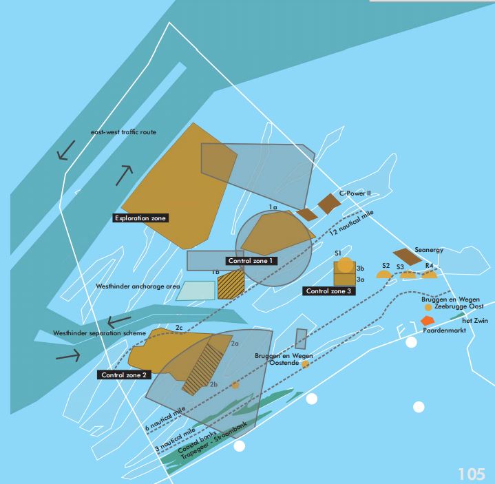
Natural values for example have received increasing attention during the last years and as a result marine protected areas have been delineated. The 'Zwin' and part of the coastal banks are protected under the Ramsar convention. Some dunes and beach areas are protected under the Habitats and / or Birds Directive and two beach reserves have been installed ('de Baai van Heist' and 'de IJzermonding). A rectangular shaped area off the Ramsar area (Flemish Banks TrapegeerStroombank) has also been proposed for integration in the Natura 2000-network (Habitats Directive). However, this area has not formally been designated. In addition, international shipping routes, areas for military exercises, areas for the different categories of the beam trawl fisheries and dumping sites for dredging materials have been established (see map).
Several marine protected areas (MPAs) have already been marked out for quite some time. The plan adds no extra MPAs but intends to improve the coordination of activities in existing areas with environmental conservation. E.g. in the special area for conservation (SAC) ‘The Flemish Banks’ (C) (named after the sandbanks) four sensitive subzones were designated, here, fishing is only allowed using environmentally friendly techniques, or under specific conditions. Also, sand and gravel exploitation is strongly limited within ‘The Flemish Banks’, and may only be done under certain conditions.
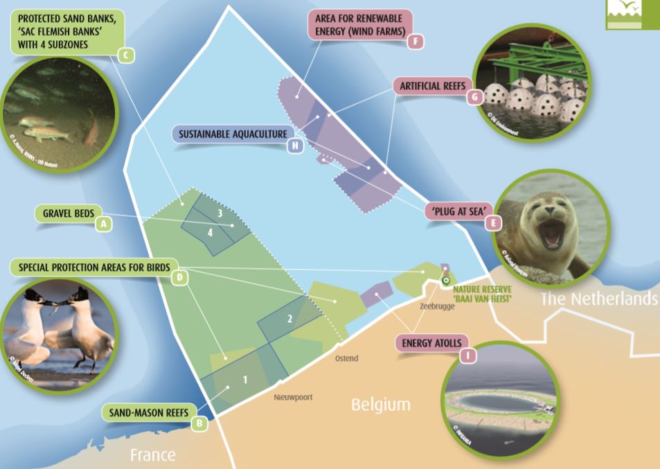
In three special protection areas for birds (D) , the existing restrictions are maintained, such as a ban on certain constructions and industrial and commercial activities. Apart from these existing protected areas, there are areas which have been designated for future activities, which do not have a disrupting impact, but which may just have a positive side effect on life at sea and in the sea:
● An area for a future ‘plug at sea’ (E) : a high-voltage station at sea to which the cables run from several wind parks and are subsequently guided from there to the mainland. For example, here a resting place for seals could be created, however, this is not compulsory for obtaining a licence to construct a power station.
● An area for wind farms and other forms of renewable energy (F) : around the existing windmills, shipping and fishing are prohibited. The cemented windmill feet will allow species like cod and bib to feed on. Crabs and shrimp appear to be much bigger when living within a wind farm. And there is also more whiting than in other parts of our North Sea. These positive effects can be stimulated. Two artificial reefs G for example, have been built in the wind farm zone in order to attract more fish and other animals. In the long term, there will be room for seals too.
● Two areas between the windmills for future sustainable aquaculture (H) , such as breeding molluscs or fish: aquaculture will be allowed here provided it reduces the fertilization (eutrophication) of the seawater in these areas.
● Two areas for future ‘energy atolls’ (I) : doughnut shaped islands where energy can be to be stored. The sand beaches of these islands have to be built in such a way that there nature can develop itself (this is required to obtain a licence to construct an atoll). For example, they will serve as breeding spots for coastal birds such as the lesser blackblacked gull, or the common tern.